Home > Other Fun Stuff > Gadgets & Hacks

Strava Global Heatmap displays 17 billion miles of recorded activity

19 Comments
Support us! Bikerumor may earn a small commission from affiliate links in this article. Learn More

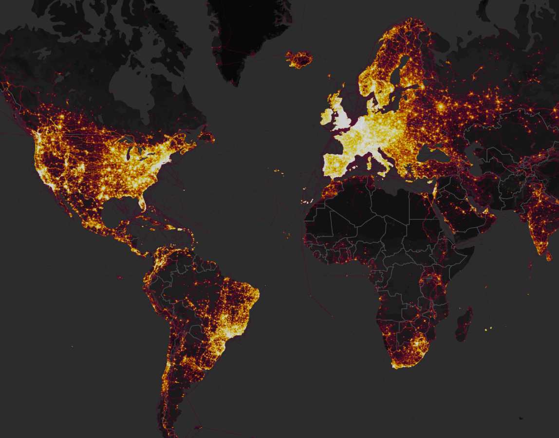
If you’re unaware of Strava’s influence in the world of athletic endeavors, their newly updated Global Heatmap makes for a powerful visual. Created to display all of the activities recorded by their extensive community of users, it’s a mind-bending amount of information and aggregates data gathered across 31 different activity types. Whether you run, ride, sea kayak, or backcountry ski, the new interactive map allows you to drill down to see where your fellow Strava members play.

See where your fellow Strava members record their activities.
My local mountain bike race course is easily spotted on the Global Heatmap interactive map.

In the time since the app first launched in 2009, Strava athletes have generated the equivalent of more than 200,000 years of recorded activity spanning 17 billion miles. If my math is correct, that’s 150 times greater than the distance to the sun. Every 40 days another million people join the community and by the time you finish reading this sentence 200 activities will have been uploaded.

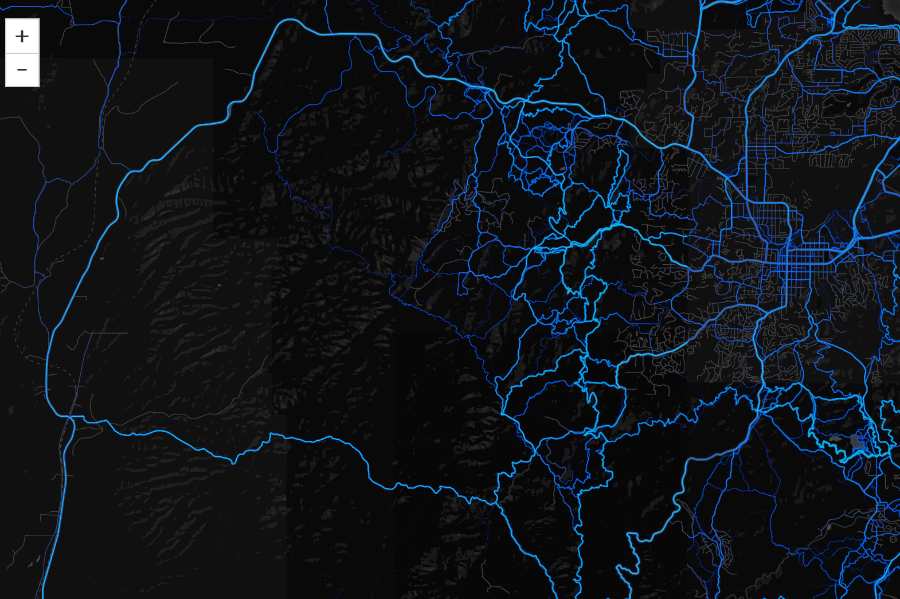
As a planning tool, the Global Heatmap has more gee-whiz factor than practical application, but it can be used to generally locate popular roads and trails, particularly in places you may not know well. After poking around the map for my area, I could quickly spot our local mountain bike race course, a route traveled by 5,000 riders over the course of just one weekend every year. The interactive map is free, but Premium Strava members can access personalized information.
Strava Metro helps government planners design routes for cyclists and pedestrians

Strava Metro is used by more than 100 communities to better plan commuting routes

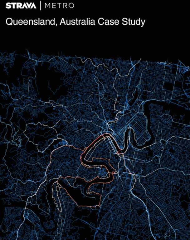
The real utility in the app stems from the crossover applications with Strava’s other tracker, Strava Metro. Like the Heatmap, Metro records user activities and formats the information specifically for use by transportation engineers and municipal planners to best maximize bike lanes and walking routes. That might be the best use of Strava collected data yet, not that we don’t love to snag a KOM/QOM now and then.

Curious how Strava started and has grown to this level? Listen to our podcast interview with co-founder Mark Gainey!

labs.strava.com

SaveSave

Subscribe
Notify of
guest

This site uses Akismet to reduce spam. Learn how your comment data is processed.

19 Comments
Oldest
Newest Most Voted
Inline Feedbacks
View all comments
Collin S
6 years ago

I love this tech. I’m heading down to Mexico for a business trip and want to get one ride in to a local mountain. Once out of the city, I can see a good route but getting out the city I was clueless. Using the strava heatmap, it made it very easy to see where others ride out to get there.

The other interesting thing is I can see the effect on the map my personal commute does. I live in a popular strava area, so there are tons of “heat” around my house, but if you follow my normal commute, where I turn off into my work’s parking lot and I enter the back door, there is a super bright line all the way to that entrance.

JBikes
JBikes
6 years ago

Although the data is useful, it does have somewhat of a catch 22 element for municipal planners/engineers as poor road planning/design will dictate what routes people currently take, even if there are technical better routes. A useful feature for Strava to mine would be origination-destination data so that bike routes can be planned but that too has an issue as poor route options may prevent people from even commuting by bike.

Bikemark
Bikemark
6 years ago
Reply to  JBikes

They’ve got origin/destination data too. I downloaded the sample dataset for the DC area. You can get a week’s worth of data from June 2016. There’s also a field for whether the ride was coded as a commute. I made my own heat map and then overlaid a map of bike facilities and the two didn’t really match up. At least two conclusions can be drawn from that: 1) the bike facilities are in the wrong places; or 2) Strava riders overrepresent the strong/fearless type and are willing to ride places that scare recreational/commuting cyclists. I think the second hypothesis is more likely than the first.

So this is a useful data point for planners but it needs to be tested against actual bike counts.

Data dude
Data dude
6 years ago

The data analyst in me screams “REVENUE, SPEND DATA” but, it’s the Cycling industry, so there’s little chance that’s important…

Collin S
6 years ago

Oh, and your math is incorrect. The sun is 93 million miles away, thus this would be 150 times larger than the distance of the sun to the earth. More impressive is in light day (the distance light would travel in a day at ~300,000,000 m/s) is 0.87 light days.

Collin S
6 years ago
Reply to  Collin S

Oops, its even bigger mistake. For some reason I was using 14B miles vs 17B miles. That puts it 182.8 earth to sun units, or 1.056 light days.

Doug
Doug
6 years ago

Best tool for finding the illegal MTB goodies in your area 🙂 haha

Jeff
Jeff
6 years ago

is this only available to premium members?

Bill Smith
Bill Smith
6 years ago
Reply to  Jeff

no, use this
labs.strava.com/heatmap

David
David
6 years ago
Reply to  Jeff

@Jeff Nope. Free to everyone. Google: strava heatmap

Flatbiller
Flatbiller
6 years ago

Holy crap, look at all the trail opportunities in the middle of Africa!

Crash Bandicoot
Crash Bandicoot
6 years ago

I wish the heatmap was a little more powerful e.g. show me heat maps of rides >50 miles. I think it could be better utilized for those of us traveling with bikes or riding new areas. Case in point in my home town of Houston there is no way that I would enjoy riding in the highlighted areas, its all heavily car trafficked and one training loop that everyone in the city uses to train on because the riding here sucks which artificially shows up on fire. There are far better more common routes just west and south of town that would be more suited to long rides and in my estimation would be easy to find if strava let us filter by ride length.

Steve
Steve
6 years ago
JBikes
JBikes
6 years ago

I question the accuracy of these. Case in point – SoCal: PCH just west I-110. Never see anyone riding it, its horrible to ride on, yet is “heavily trafficked”

Collin
Collin
6 years ago
Reply to  JBikes

If it’s just one guys commute, it will show up “hot”. I have a super hot area going up my works driveway because I have been up and down that long driveway over 400 times.

JBikes
JBikes
6 years ago
Reply to  Collin

Interesting. I don’t know how they parse the use data, but I’d think it would have a number of users/per capita component.

Christian Huot
Christian Huot
6 years ago

Great heat map. I just wish Strava had decent maps. The city where I live, Ottawa, has hundreds of kilometers of bike paths but Strava shows none of them. If I map a ride it shows as me riding a blank space. It’s almost as if it’s designed for drivers.

Ryan S.
Ryan S.
6 years ago

I see trails that have been closed for years showing up though, so this is way more than 2017. Something to keep in mind if using this for finding “secret” trails. Case in point, you’d be riddled by bullets taking a closed trail in my area as it’s the local FBI and police shooting range now.

Subscribe Now

Sign up to receive BikeRumor content direct to your inbox.

Subscribe Now

Sign up to receive BikeRumor content direct to your inbox.